GLY560 Method:
Correlation of Thermal Imagery to Lake Characteristics, Northern Highland Lakes Region, Vilas County, Wisconsin
Abstract:
This method describes a procedure for correlating lake characteristics to remotely sensed thermal imagery. Properties such as depth and volume may be ascertained by analyzing thermal responses if correlation is high. During the night, materials such as soil, rock and vegetation lose heat to the atmosphere while water retains much of its heat. Nighttime thermal imaging can detect these temperature variations, along with more subtle gradations within different media. ASTER (Advanced Spaceborne Thermal Emission and Reflection Radiometer) is an imaging instrument on the Terra satellite launched in 1999 as part of NASA's EOS program. For the purposes of correlating thermal imagery, ASTER's Level 8 Kinetic Temperature data was used. An example is presented for the Northern Highland Lakes Region of Vilas County, Wisconsin. By developing techniques for lake characterization, uses for remote sensing can be expanded. This data may be used for improving ground-water and surface water modeling, as well as integration into comprehensive hydrologic cycle models.
Keywords:
Lakes, Thermal, Kinetic Temperature
Software Used:
- ENVI 3.4 or higher
- ArcView 3.1 or higher
- Microsoft Excel
Data Used:
For this project, several remotely sensed images were aquired. An ASTER Level 1B Radiance at the Sensor image was obtained for classification. An ASTER Level 8 Registered 30 meter thermal image was used for kinetic temperature analysis. Surface kinetic temperature is reported with cell values representing the kinetic temperature (Kelvin*10). All the images are nighttime scenes from October 11, 2000. The thermal image was compared to lake characteristics maintained in a database in ArcView compiled from a USGS DEM and the Wisconsin Department of Natural Resources. The DEM was downloaded from the Cornell University geospatial repository.
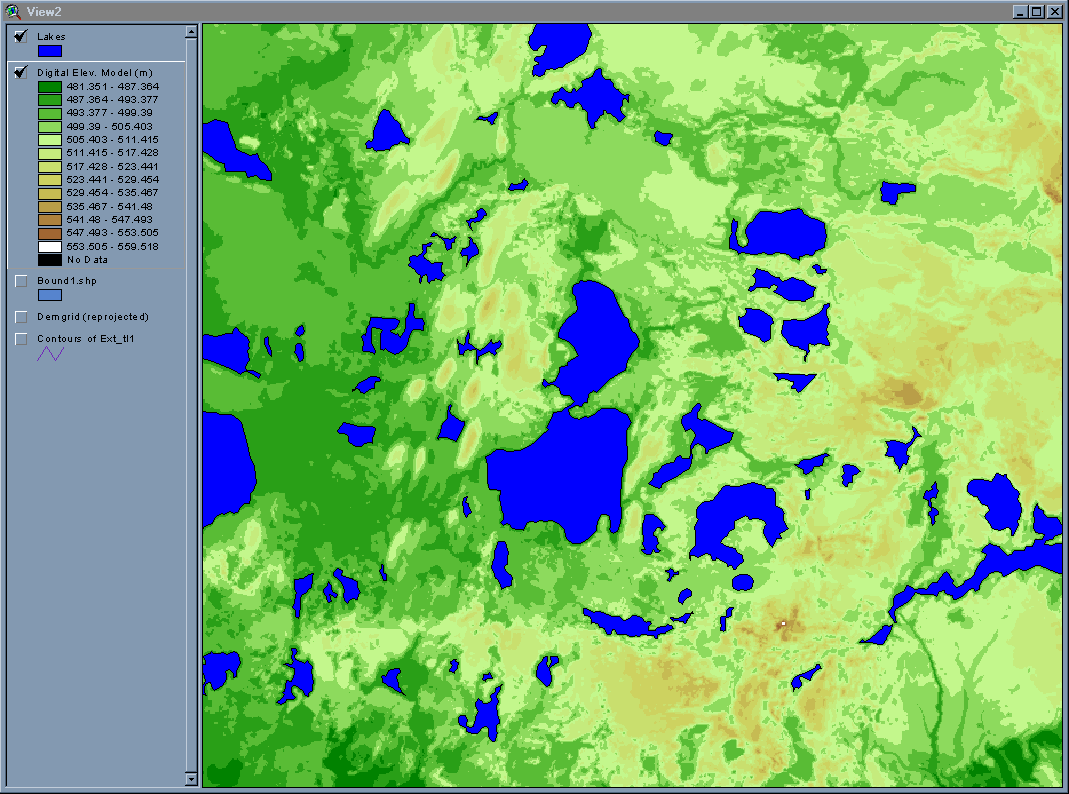
The ArcView project was built from the ground up, starting with the DEM. (For the main view of the ArcView project, click here.) Lakes were delineated by ArcView contours. Flat areas were compared to area maps, and polygons were drawn for lake boundaries. Lake depths were collected from the Wisconsin DNR web site for Vilas County, Wisconsin. Lake temperatures are from the approximate geometric center of the lake, while depths are the maximum reported depth.
Example Application and Procedure:
This section will describe an example for the Trout Lake basin lake characterization. It will also provide step-by-step instructions for trying this method on your own. For a geographic reference and brief background of the study area, please navigate to the Wisconsin link.
Remotely sensed data can be acquired from several sources. Since ASTER data is free and easy to retrieve, and it has thermal bands available, it is the data that was used for this method. In order to download ASTER scenes, follow the directions outlined by the EOS Data Gateway. The easiest data retrieval is at the EOS Gateway, by registering and entering the search site as a registered user. From this point, the directions are clear for ordering and downloading your free ASTER scenes.
For a simple supervised classification of surface temperature response, follow the directions below:
- Open ENVI 3.4 (or 3.5) and go to File->Open Data File. Below you see the ENVI main toolbar that appears in the top left of your screen when ENVI is open. ENVI uses a floating window system. Each display will have three image windows of various scales.

- Navigate to the file you would like to view. In this case, it is the 30 meter registered image.
- Select the file.
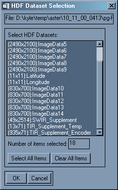
- The HDF Dataset Selection dialog appears, choose "Select All Items." Once the files are selected, the dialog should look like this:
- Choose OK. The Available Bands dialog appears.
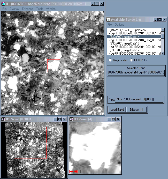
- Select Image Data 14 (any one between 10 and 14 will work) and choose Gray Scale.
- Click Load Band. The image below shows the red square in the Image window around the southern basin of Trout Lake.
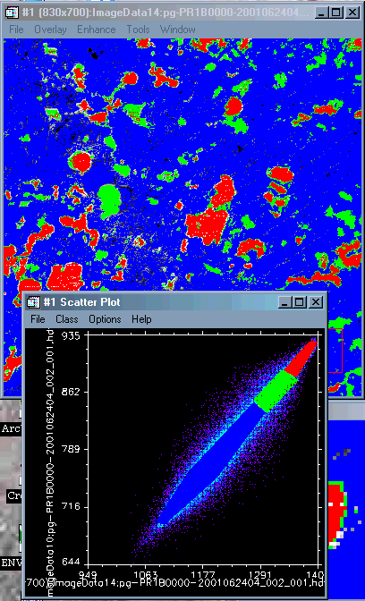
- In the Image window, choose Tools -> 2D Scatter Plots. Select two of the thermal bands. I used 14 and 12 for my example. The Scatter Plot will appear.
- Go to Options -> Density On, to add color to the scatter plot to show pixel density.
- Go to the image window and hold down the left mouse button. Move it around in a like-colored area. Small dots will appear to "dance" in the scatter plot.
For my example, I have outlined (classified) three different classes. I selected the brightest, or warmest areas to be one class, the darkest, or coolest areas to be another, with a third class in the middle, toward the brighter side of the spectrum.
- To make the classes, go to the scatter plot window. Hold the left mouse button down to draw a shape, or click to draw a polygon around a class. Right click to close the area.
- Go to Class -> Items 1 - 20 to select a color for your next class. Do this again for the third. You will see, as you close your shapes in the scatter plot, that the pixels shown are colored in the Image and Zoom windows as they are in the 2D scatter plot. Notice in the figure below, Trout Lake is warm as shown by the red class.
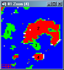
Even from this simple classification, it is easy to see that the lakes (green=cooler and red=warmer) have different thermal responses from each other, as well as within a single lake. Below, the largest lake is called Big Muskellunge Lake (denoted by the number 2). Its maximum depth is relatively deep (70 ft), but the southern intralake basin (3) is much shallower (5 ft). You can see here that the shallow basin cools more quickly than the deeper parts of the lake. Also, note the differences between Little John Lake (1) and Crystal Lake (4). Little John Lake is 19 feet deep with a surface area of 166 acres. Crystal Lake has a surface area of only 88 acres, but is 67 feet deep.
In order to use kinetic surface temperature, the Level 8 data must be loaded into ENVI. This data is necessary for the following correlation analysis:
- Go to the Available Bands dialog box and click File -> Open Image File. Navigate to your level 8 image. In this case, it is a 30 meter registered image. Gray scale is the selected display.
- Go to the bottom and click Display #1 -> New Display. A blank display will appear called Display #2. Select Load Band. The Level 8 image should appear in the new display window. In the image below, Trout Lake is pointed out to orient the photo for you.
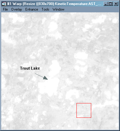
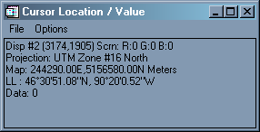
- In the Display #2 window, select Tools -> Cursor Location/Value. A box will appear. Notice what happens when you move your cursor around in the Image window. It is showing you the coordinates of the cursor and the registration data, as well as a value (Data). For the level 8 image, this value is the Surface Kinetic temperature, a value of Kelvin*10.
The correlation portion of this project was done manually. Although there may be more efficient methods using ENVI and ArcView in concert, time and knowledge constraints were limiting factors, making manual data entry the most appealing option. By using the Cursor Locator and placing it over the geometric center of the lake, the kinetic temperature could be read and recorded. This value was entered into the lake database, using Microsoft Excel. The process was repeated, selecting arbitrary lakes in the region to get a representative sample. The total number of lakes included in the analysis is 111 of the 540 total lakes within Vilas County.
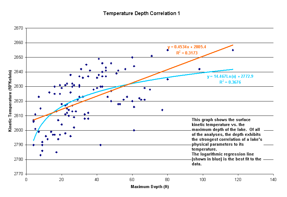
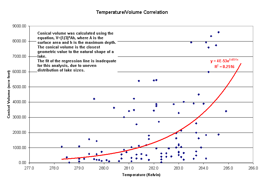
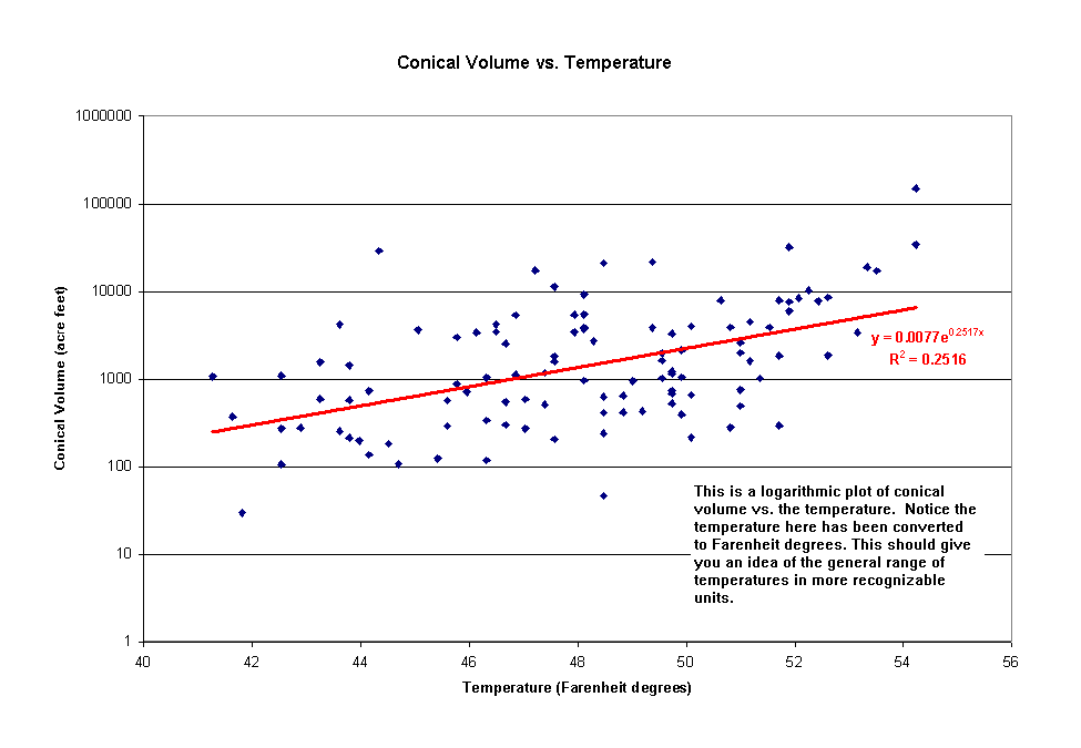
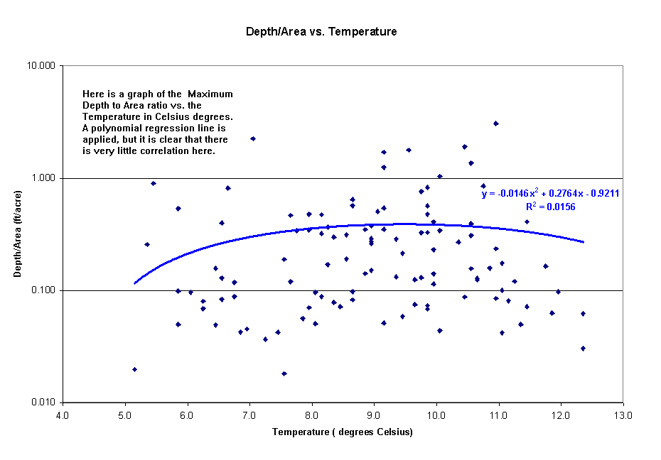
Using Excel, several graphs correlating lake characteristics with kinetic temperature were made. Click on the links below to see examples.
References:
Conclusions:
Remote sensing imagery holds vast potential for many facets of science and research. New and exciting ways to use remote sensing are found everyday. Using these images to distinguish surface characteristics can provide accurate, efficient, and cost-effective alternatives to intensive field reconnaisance.
This method shows that thermal imagery can be used to distinguish lake characteristics. By evaluating these properties, scientists may be able to use remote sensing for limnological research, as well as for improving surface water and ground-water models.
Last Modified: May 8, 2002
Back to Top